Geolocate

Syange topographic map

Click on the map to display elevation.

About this map

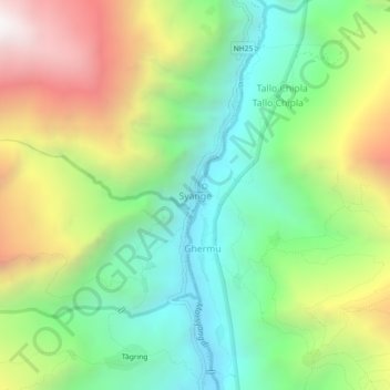
Name: Syange topographic map, elevation, terrain.

Location: Syange, Marsyangdi, Lamjung, Gandaki Province, Nepal (28.36727 84.38205 28.40727 84.42205)

Average elevation: 5,623 ft

Minimum elevation: 3,419 ft

Maximum elevation: 9,167 ft

Other topographic maps

Click on a map to view its topography, its elevation and its terrain.

Rainas-03

Nepal > Gandaki Province > Lamjung

Average elevation: 2,923 ft

Sundarbazar

Nepal > Gandaki Province > Lamjung

Average elevation: 3,143 ft

Palase

Nepal > Gandaki Province > Lamjung

Average elevation: 2,933 ft

Madhya Nepal-06

Nepal > Gandaki Province > Lamjung

Average elevation: 2,221 ft

Besishahar

Nepal > Gandaki Province > Lamjung

Average elevation: 3,875 ft

Besishahar

Nepal > Gandaki Province > Lamjung

Average elevation: 3,875 ft

Gear up for your next adventure:

🪶Fire Starter Kit - Reliable fire starter for survival and camping
🕶️GPS Smartphone Mount - Secure mount for phone navigation
🧥Men's Rain Shells - Premium waterproof and breathable jackets for mountain weather
🔦Compact Flashlight - Reliable flashlight for emergencies
🧭Outdoor Navigation Book - Learn advanced navigation skills

As an Amazon Associate, this site earns from qualifying purchases at no extra cost to you.