Geolocate

Wallis topographic map

Click on the map to display elevation.

About this map

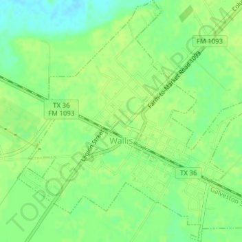
Name: Wallis topographic map, elevation, terrain.

Location: Wallis, Austin County, Texas, 77485, United States (29.62001 -96.07868 29.64718 -96.04894)

Average elevation: 131 ft

Minimum elevation: 102 ft

Maximum elevation: 141 ft

Austin County trails, hiking, mountain biking, running and outdoor activities

Other topographic maps

Click on a map to view its topography, its elevation and its terrain.

Kenney

United States > Texas > Austin County

Average elevation: 335 ft

Alligator Hole

United States > Texas > Austin County

Average elevation: 105 ft

Frydek

United States > Texas > Austin County

Average elevation: 151 ft

Burleigh

United States > Texas > Austin County

Average elevation: 171 ft

Cat Spring

United States > Texas > Austin County

Average elevation: 295 ft

New Wehdem

United States > Texas > Austin County

Average elevation: 354 ft

Gear up for your next adventure:

🌡️Portable Weather Meter - Track weather conditions on the trail
📡Handheld GPS Device - Reliable handheld GPS for outdoor navigation
🎒Hydration Pack - Hands‑free water reservoir for long hikes
⛑️Personal Locator Beacon - Safety beacon for emergencies
🚑Emergency Bivvies - Heat-reflective sleeping bags for survival situations

As an Amazon Associate, this site earns from qualifying purchases at no extra cost to you.