Geolocate

Oakland topographic map

Click on the map to display elevation.

About this map

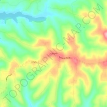
Name: Oakland topographic map, elevation, terrain.

Location: Oakland, Marion County, Arkansas, 72661, United States (36.44090 -92.59100 36.48090 -92.55100)

Average elevation: 850 ft

Minimum elevation: 643 ft

Maximum elevation: 1,125 ft

Marion County trails, hiking, mountain biking, running and outdoor activities

Other topographic maps

Click on a map to view its topography, its elevation and its terrain.

Summit

United States > Arkansas > Marion County

Average elevation: 876 ft

Bull Shoals

United States > Arkansas > Marion County

Average elevation: 692 ft

Pyatt

United States > Arkansas > Marion County

Average elevation: 853 ft

Gear up for your next adventure:

Backpacking Tents - Weight-optimized shelters for multi-day topographic surveys
Camping Coffee Makers - Enjoy premium coffee at the summit or campsite
👟Men's Trail Runners - Lightweight footwear for fast-paced exploration and light hiking
🔭Compact Binoculars - HD vision for scouting terrain and identifying distant landmarks
🎒Trail Energy Bars - High‑calorie bars for hiking energy

As an Amazon Associate, this site earns from qualifying purchases at no extra cost to you.