Geolocate

Pyatt topographic map

Click on the map to display elevation.

About this map

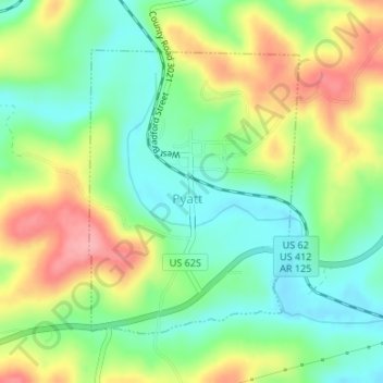
Name: Pyatt topographic map, elevation, terrain.

Location: Pyatt, Marion County, Arkansas, 72672, United States (36.24048 -92.85305 36.26047 -92.83465)

Average elevation: 853 ft

Minimum elevation: 702 ft

Maximum elevation: 1,076 ft

Marion County trails, hiking, mountain biking, running and outdoor activities

Other topographic maps

Click on a map to view its topography, its elevation and its terrain.

Summit

United States > Arkansas > Marion County

Average elevation: 876 ft

Bull Shoals

United States > Arkansas > Marion County

Average elevation: 692 ft

Bull Shoals

United States > Arkansas > Marion County > Bull Shoals

Average elevation: 692 ft

Bruno

United States > Arkansas > Marion County

Average elevation: 1,047 ft

Oakland

United States > Arkansas > Marion County

Average elevation: 850 ft

Peel

United States > Arkansas > Marion County

Average elevation: 801 ft

Gear up for your next adventure:

📱Solar Portable Charger - Solar power bank for charging devices off‑grid
🪶LED Camping Lantern - Bright lantern for camp lighting
🥄Camping Utensil Set - Lightweight utensils for outdoor meals
🪵Folding Camp Saw - Compact saw for wood and campsite work
🩳Quick‑Dry Hiking Shorts - Comfortable and quick‑dry shorts for summer hiking

As an Amazon Associate, this site earns from qualifying purchases at no extra cost to you.