Geolocate

Syzran topographic map

Click on the map to display elevation.

About this map

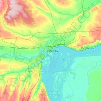
Name: Syzran topographic map, elevation, terrain.

Location: Syzran, Samara Oblast, Volga Federal District, 446001, Russia (52.99538 48.31412 53.31538 48.63412)

Average elevation: 302 ft

Minimum elevation: 75 ft

Maximum elevation: 919 ft

Gear up for your next adventure:

🧣Hiking Neck Gaiter - Multi‑use neck protection for outdoor weather
🏕️Tent Footprint - Protect your tent base from wear
🛰️Handheld GPS Units - Professional satellite navigators for precise backcountry mapping
🌧️Backpack Rain Cover - Keep gear dry in wet weather
🍳Camping Cook Set - Complete cookware for outdoor meals

As an Amazon Associate, this site earns from qualifying purchases at no extra cost to you.