
Make a donation
Gear up for your next adventure:
As an Amazon Associate, this site earns from qualifying purchases at no extra cost to you.
Paternion topographic map
Click on the map to display elevation.
Make a donation
Gear up for your next adventure:
As an Amazon Associate, this site earns from qualifying purchases at no extra cost to you.
About this map
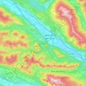
Name: Paternion topographic map, elevation, terrain.
Location: Paternion, Bezirk Villach-Land, Carinthia, 9711, Austria (46.63610 13.42998 46.74311 13.71700)
Average elevation: 3,291 ft
Minimum elevation: 1,624 ft
Maximum elevation: 7,060 ft
Make a donation
Gear up for your next adventure:
As an Amazon Associate, this site earns from qualifying purchases at no extra cost to you.
Other topographic maps
Click on a map to view its topography, its elevation and its terrain.
Faak am See
Austria > Carinthia > Bezirk Villach-Land > Finkenstein am Faaker See > Faak am See
Average elevation: 1,972 ft
Wurzach
Austria > Carinthia > Bezirk Villach-Land > Bad Bleiberg > Bleiberg-Kreuth
Average elevation: 3,891 ft
Make a donation
Gear up for your next adventure:
As an Amazon Associate, this site earns from qualifying purchases at no extra cost to you.
Frießnitz/Breznica
Austria > Carinthia > Bezirk Villach-Land > St. Jakob im Rosental
Average elevation: 1,834 ft
Köstenberg
Austria > Carinthia > Bezirk Villach-Land > Velden am Wörther See
Average elevation: 2,700 ft
Oberwinklern
Austria > Carinthia > Bezirk Villach-Land > Velden am Wörther See
Average elevation: 2,470 ft
Make a donation
Gear up for your next adventure:
As an Amazon Associate, this site earns from qualifying purchases at no extra cost to you.
Semering
Austria > Carinthia > Bezirk Villach-Land > Nötsch im Gailtal > Kühweg
Average elevation: 2,710 ft
Make a donation
Gear up for your next adventure:
As an Amazon Associate, this site earns from qualifying purchases at no extra cost to you.