
Make a donation
Gear up for your next adventure:
As an Amazon Associate, this site earns from qualifying purchases at no extra cost to you.
Annenheim topographic map
Click on the map to display elevation.
Make a donation
Gear up for your next adventure:
As an Amazon Associate, this site earns from qualifying purchases at no extra cost to you.
About this map
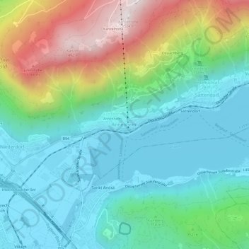
Name: Annenheim topographic map, elevation, terrain.
Average elevation: 2,582 ft
Minimum elevation: 1,617 ft
Maximum elevation: 4,984 ft
Make a donation
Gear up for your next adventure:
As an Amazon Associate, this site earns from qualifying purchases at no extra cost to you.
Other topographic maps
Click on a map to view its topography, its elevation and its terrain.
Lake Faak
Austria > Carinthia > Bezirk Villach-Land > Finkenstein am Faaker See > Faak am See
Average elevation: 1,877 ft
Make a donation
Gear up for your next adventure:
As an Amazon Associate, this site earns from qualifying purchases at no extra cost to you.
Nötsch im Gailtal
Austria > Carinthia > Bezirk Villach-Land > Nötsch im Gailtal
Average elevation: 3,169 ft