
Make a donation
Gear up for your next adventure:
As an Amazon Associate, this site earns from qualifying purchases at no extra cost to you.
Armañanzas topographic map
Click on the map to display elevation.
Make a donation
Gear up for your next adventure:
As an Amazon Associate, this site earns from qualifying purchases at no extra cost to you.
Armañanzas
La villa de Armañanzas está situada en la parte occidental de la Comunidad Foral de Navarra, dentro de la región geográfica de la Zona Media de Navarra o Navarra Media, a una altitud de 497 m s. n. m. Su término municipal tiene una superficie de 12,38 km² y limita al norte con los municipios de Espronceda y Desojo, al este con los de Sansol y Torres del Río y al sureste con el de Bargota.
Make a donation
Gear up for your next adventure:
As an Amazon Associate, this site earns from qualifying purchases at no extra cost to you.
About this map
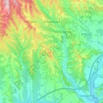
Name: Armañanzas topographic map, elevation, terrain.
Location: Armañanzas, Montejurra, España (42.48675 -2.30687 42.58008 -2.27239)
Average elevation: 1,614 ft
Minimum elevation: 1,237 ft
Maximum elevation: 2,582 ft
Make a donation
Gear up for your next adventure:
As an Amazon Associate, this site earns from qualifying purchases at no extra cost to you.
Other topographic maps
Click on a map to view its topography, its elevation and its terrain.