
Make a donation
Gear up for your next adventure:
As an Amazon Associate, this site earns from qualifying purchases at no extra cost to you.
Aldea Suyapa topographic map
Click on the map to display elevation.
Make a donation
Gear up for your next adventure:
As an Amazon Associate, this site earns from qualifying purchases at no extra cost to you.
About this map
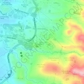
Name: Aldea Suyapa topographic map, elevation, terrain.
Average elevation: 3,655 ft
Minimum elevation: 3,353 ft
Maximum elevation: 4,216 ft
Make a donation
Gear up for your next adventure:
As an Amazon Associate, this site earns from qualifying purchases at no extra cost to you.
Other topographic maps
Click on a map to view its topography, its elevation and its terrain.
Aldea Villa Vieja
Honduras > Francisco Morazán > Tegucigalpa > Aldea Villa Vieja
Average elevation: 4,147 ft
Colonia CentroAmericana
Honduras > Francisco Morazán > Tegucigalpa > Comayagüela
Average elevation: 3,189 ft
Make a donation
Gear up for your next adventure:
As an Amazon Associate, this site earns from qualifying purchases at no extra cost to you.
Make a donation
Gear up for your next adventure:
As an Amazon Associate, this site earns from qualifying purchases at no extra cost to you.