Geolocate

Termoli topographic map

Click on the map to display elevation.

About this map

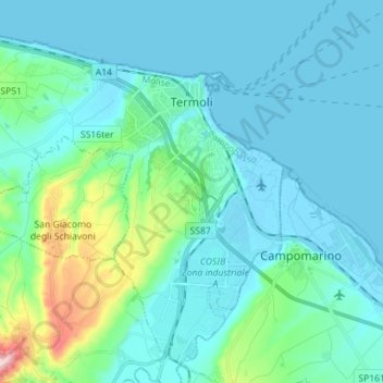
Name: Termoli topographic map, elevation, terrain.

Location: Termoli, Campobasso, Molise, 86039, Italy (41.92609 14.88990 42.02148 15.03102)

Average elevation: 141 ft

Minimum elevation: -10 ft

Maximum elevation: 981 ft

Other topographic maps

Click on a map to view its topography, its elevation and its terrain.

Bosco Mazzocca

Italy > Molise > Campobasso > Riccia

Average elevation: 2,618 ft

Mancini

Italy > Molise > Campobasso > Riccia

Average elevation: 2,654 ft

Gear up for your next adventure:

🔥Plasma Lighters - Windproof lighters that work in any weather condition
🚗GPS Dash Cams - Record your scenic drives through mountain passes and canyons
📷Action Camera - Capture your outdoor adventures in HD
🧭Orienteering Set - Complete compass and map reading kit
🔦Powerful Headlamps - Ultra-bright hands-free lighting for night navigation

As an Amazon Associate, this site earns from qualifying purchases at no extra cost to you.