Geolocate

Sutton Valence topographic map

Click on the map to display elevation.

About this map

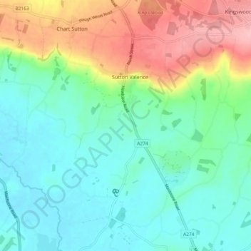
Name: Sutton Valence topographic map, elevation, terrain.

Location: Sutton Valence, Maidstone, Kent, England, United Kingdom (51.17303 0.56567 51.23009 0.60679)

Average elevation: 180 ft

Minimum elevation: 46 ft

Maximum elevation: 476 ft

Other topographic maps

Click on a map to view its topography, its elevation and its terrain.

Bletchingly

United Kingdom > England > Kent > Maidstone

Average elevation: 121 ft

Detling Hill

United Kingdom > England > Kent > Maidstone

Average elevation: 499 ft

Mote Park

United Kingdom > England > Kent > Maidstone > Otham

Average elevation: 171 ft

Broomfield

United Kingdom > England > Kent > Maidstone > Leeds

Average elevation: 315 ft

Langley Park

United Kingdom > England > Kent > Maidstone > Langley

Average elevation: 315 ft

Bicknor Wood

United Kingdom > England > Kent > Maidstone > Otham

Average elevation: 279 ft

Laddingford

United Kingdom > England > Kent > Maidstone > Yalding

Average elevation: 46 ft

Kingswood

United Kingdom > England > Kent > Maidstone

Average elevation: 358 ft

East Lenham

United Kingdom > England > Kent > Maidstone > Lenham

Average elevation: 417 ft

Linton

United Kingdom > England > Kent > Maidstone

Average elevation: 233 ft

Liverton Street

United Kingdom > England > Kent > Maidstone > Grafty Green

Average elevation: 335 ft

Westfield Sole

United Kingdom > England > Kent > Maidstone

Average elevation: 476 ft

Lenham Heath

United Kingdom > England > Kent > Maidstone

Average elevation: 315 ft

Leadingcross Green

United Kingdom > England > Kent > Maidstone > Lenham

Average elevation: 387 ft

Bletchenden

United Kingdom > England > Kent > Maidstone > Headcorn

Average elevation: 79 ft

Walderslade Woods

United Kingdom > England > Kent > Maidstone

Average elevation: 509 ft

Harpole

United Kingdom > England > Kent > Maidstone > Detling

Average elevation: 338 ft

Weavering Park

United Kingdom > England > Kent > Maidstone > Grove Green

Average elevation: 184 ft

Eyhorne Street

United Kingdom > England > Kent > Maidstone > Hollingbourne

Average elevation: 295 ft

Gear up for your next adventure:

👖Convertible Hiking Pants - Versatile zip-off pants for changing altitudes and temperatures
🧦Hiking Socks - Comfortable socks to prevent blisters on long hikes
🎒Gear Packing Cubes - Organize your backpack efficiently
📷Action Cameras - Rugged cameras to document your journeys across rugged terrain
🪶Multi‑Purpose Knife - Useful blade for camp and trail

As an Amazon Associate, this site earns from qualifying purchases at no extra cost to you.