
Dubréka topographic map
Interactive map
Click on the map to display elevation.
About this map
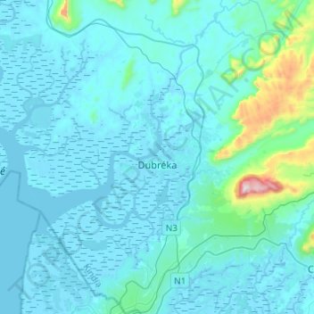
Name: Dubréka topographic map, elevation, terrain.
Location: Dubréka, Kindia Region, Guinea (9.67444 -13.56597 9.91531 -13.41661)
Average elevation: 262 ft
Minimum elevation: -26 ft
Maximum elevation: 3,209 ft
Other topographic maps
Click on a map to view its topography, its elevation and its terrain.
Sambayah
Guinea > Kindia Region > Coyah
Sambayah, Coyah, Kindia Region, Guinea
Average elevation: 125 ft