
Make a donation
Gear up for your next adventure:
As an Amazon Associate, this site earns from qualifying purchases at no extra cost to you.
Salares topographic map
Click on the map to display elevation.
Make a donation
Gear up for your next adventure:
As an Amazon Associate, this site earns from qualifying purchases at no extra cost to you.
About this map
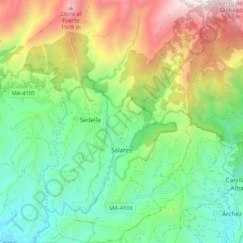
Name: Salares topographic map, elevation, terrain.
Location: Salares, La Axarquía, Malaga, Andalousie, Espagne (36.83178 -4.03813 36.89068 -3.98725)
Average elevation: 2,615 ft
Minimum elevation: 1,122 ft
Maximum elevation: 5,276 ft
Make a donation
Gear up for your next adventure:
As an Amazon Associate, this site earns from qualifying purchases at no extra cost to you.
Other topographic maps
Click on a map to view its topography, its elevation and its terrain.
Castillo de Benthomiz
Espagne > Andalousie > La Axarquía > Arenas
Le château de Bentomiz, est une ancienne forteresse construite sur un coteau, proche du village espagnol d'Arenas, dans la province andalouse de Malaga, à 711 mètres d'altitude. Cette forteresse notée sur un document signé par Abd Allah, roi zirí de Grenade au XI siècle, fut reprise par le roi…
Average elevation: 1,411 ft
Make a donation
Gear up for your next adventure:
As an Amazon Associate, this site earns from qualifying purchases at no extra cost to you.
Las Casillas
Espagne > Andalousie > La Axarquía > Rincón de la Victoria > Las Casillas
Average elevation: 299 ft