Geolocate

Upper Village topographic map

Click on the map to display elevation.

About this map

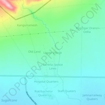
Name: Upper Village topographic map, elevation, terrain.

Location: Upper Village, Kisumu County, Nyanza, Kenya (-0.06523 34.95880 -0.02523 34.99880)

Average elevation: 4,088 ft

Minimum elevation: 3,917 ft

Maximum elevation: 4,711 ft

Other topographic maps

Click on a map to view its topography, its elevation and its terrain.

Maseno

Kenya > Kisumu County > Kisumu West

Average elevation: 5,030 ft

Osiri sublocation

Kenya > Kisumu County > Kisumu West

Average elevation: 3,829 ft

Muhoroni

Kenya > Kisumu County

Average elevation: 5,089 ft

Gear up for your next adventure:

💧Water Purification System - Clean water on the trail with reliable purifiers
🏕️Family Camping Gear - Essentials for group camping trips
📦Dry Bags Set - Waterproof storage for electronics and clothes
📻Weather Alert Radios - Stay informed of storm risks while off-the-grid
🧦Merino Wool Socks - Moisture-wicking, blister-preventing socks for long treks

As an Amazon Associate, this site earns from qualifying purchases at no extra cost to you.