
Make a donation
Gear up for your next adventure:
As an Amazon Associate, this site earns from qualifying purchases at no extra cost to you.
Bear Lake topographic map
Click on the map to display elevation.
Make a donation
Gear up for your next adventure:
As an Amazon Associate, this site earns from qualifying purchases at no extra cost to you.
About this map
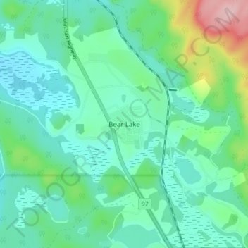
Name: Bear Lake topographic map, elevation, terrain.
Average elevation: 2,382 ft
Minimum elevation: 2,244 ft
Maximum elevation: 2,861 ft
Make a donation
Gear up for your next adventure:
As an Amazon Associate, this site earns from qualifying purchases at no extra cost to you.
Other topographic maps
Click on a map to view its topography, its elevation and its terrain.
Crooked River
Canada > British Columbia > Regional District of Fraser-Fort George > Area G (Crooked River/Parsnip)
Average elevation: 2,457 ft
Carp Lake
Canada > British Columbia > Regional District of Fraser-Fort George > Area G (Crooked River/Parsnip)
Average elevation: 2,838 ft
Salmon Lake
Canada > British Columbia > Regional District of Fraser-Fort George > Area G (Crooked River/Parsnip)
Average elevation: 2,982 ft
Summit Lake
Canada > British Columbia > Regional District of Fraser-Fort George > Area G (Crooked River/Parsnip) > Summit Lake
Summit Lake, elevation 710 m (2329 ft), is a lake in the Central Interior of British Columbia, Canada, located to the north of the city of Prince George. It is the namesake of the community of the same name, which lies alongside the John Hart Highway to the south of the community of McLeod Lake (Fort McLeod).…
Average elevation: 2,392 ft
Make a donation
Gear up for your next adventure:
As an Amazon Associate, this site earns from qualifying purchases at no extra cost to you.
Davie Lake
Canada > British Columbia > Regional District of Fraser-Fort George > Area G (Crooked River/Parsnip)
Average elevation: 2,356 ft
Mugaha Marsh
Canada > British Columbia > Regional District of Fraser-Fort George > Area G (Crooked River/Parsnip)
Average elevation: 2,234 ft
Tacheeda Lakes
Canada > British Columbia > Regional District of Fraser-Fort George > Area G (Crooked River/Parsnip)
Average elevation: 2,871 ft
Coyote Lake
Canada > British Columbia > Regional District of Fraser-Fort George > Area G (Crooked River/Parsnip)
Average elevation: 2,785 ft
Make a donation
Gear up for your next adventure:
As an Amazon Associate, this site earns from qualifying purchases at no extra cost to you.