
Muar topographic map
Click on the map to display elevation.
About this map
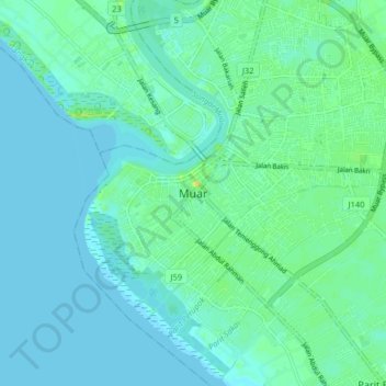
Name: Muar topographic map, elevation, terrain.
Location: Muar, Johor, 84000, Malaysia (1.88250 102.40589 2.20250 102.72589)
Average elevation: 23 ft
Minimum elevation: 0 ft
Maximum elevation: 705 ft
Other topographic maps
Click on a map to view its topography, its elevation and its terrain.
Aur Island
The west coast of Aur Island is influenced by the southwest monsoon that blows the wind from the Straits of Malacca during the months of May to September. The periods between the monsoons are usually marked by heavy rainfall. The mountains have lower temperature range due to their higher altitude and the…
Average elevation: 305 ft
Parit Bukit Batu Pasir
Malaysia > Johor > Batu Pahat > Kampung Bukit Batu Pasir Darat
Average elevation: 16 ft