Geolocate

Moyar topographic map

Click on the map to display elevation.

About this map

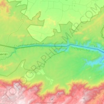
Name: Moyar topographic map, elevation, terrain.

Location: Moyar, Gundlupet taluk, Chamarajanagar district, Karnataka, India (11.57886 76.58027 11.61790 76.84852)

Average elevation: 3,491 ft

Minimum elevation: 1,283 ft

Maximum elevation: 7,411 ft

Other topographic maps

Click on a map to view its topography, its elevation and its terrain.

Hasaguli

India > Karnataka > Gundlupet taluk

Average elevation: 2,618 ft

Bandipura

India > Karnataka > Gundlupet taluk

Average elevation: 3,320 ft

Gundlupet

India > Karnataka > Gundlupet taluk

Gundlupet is located at 11°48′N 76°41′E / 11.8°N 76.68°E / 11.8; 76.68. It has an average elevation of 816 metres (2,677 feet).

Average elevation: 2,648 ft

Basavapura

India > Karnataka > Gundlupet taluk

Average elevation: 2,707 ft

Toravalli

India > Karnataka > Gundlupet taluk

Average elevation: 2,369 ft

Gear up for your next adventure:

🏕️Tent Footprint - Protect your tent base from wear
📡Handheld GPS Device - Reliable handheld GPS for outdoor navigation
🗻Climbing Gear Basics - Essential gear for beginner climbers
🪶Multi‑Purpose Knife - Useful blade for camp and trail
🗃️Trail First Aid Kit - Essential kit for outdoor injuries and emergencies

As an Amazon Associate, this site earns from qualifying purchases at no extra cost to you.