Geolocate

Tardienta topographic map

Click on the map to display elevation.

About this map
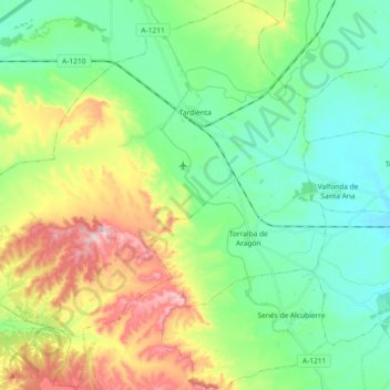
Name: Tardienta topographic map, elevation, terrain.

Location: Tardienta, Los Monegros, Huesca, Aragon, 22240, Spain (41.88102 -0.65215 42.01746 -0.48386)

Average elevation: 1,398 ft

Minimum elevation: 1,096 ft

Maximum elevation: 2,054 ft

Other topographic maps

Click on a map to view its topography, its elevation and its terrain.

Bujaraloz

Spain > Aragon > Los Monegros > Bujaraloz

Average elevation: 1,089 ft

Montemar

Spain > Aragon > Los Monegros > Farlete

Average elevation: 2,146 ft

Ordesa

Spain > Aragon > Los Monegros > Almuniente

Average elevation: 1,119 ft

Gear up for your next adventure:

🎒Hydration Pack - Hands‑free water reservoir for long hikes
🪶Compact Camp Shovel - Folding shovel for campsite tasks
⌚Solar GPS Watches - Advanced multisport watches with built-in topographic maps
📶Vehicle Signal Boosters - Improve reception in rural areas while driving to trailheads
🔭Compact Binoculars - HD vision for scouting terrain and identifying distant landmarks

As an Amazon Associate, this site earns from qualifying purchases at no extra cost to you.