
Bearwallow Mountain topographic map
Interactive map
Click on the map to display elevation.
About this map
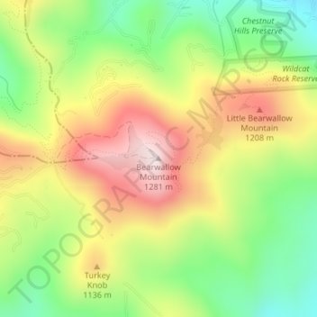
Name: Bearwallow Mountain topographic map, elevation, terrain.
Average elevation: 3,412 ft
Minimum elevation: 2,684 ft
Maximum elevation: 4,229 ft
Henderson County trails, hiking, mountain biking, running and outdoor activities
Other topographic maps
Click on a map to view its topography, its elevation and its terrain.
Kanuga Lake
United States > North Carolina > Henderson County > Kanuga Ridge
Average elevation: 2,356 ft
Echo Lake
United States > North Carolina > Henderson County > Laurel Park > Country Ridge
Average elevation: 2,493 ft
Mills River
United States > North Carolina > Henderson County > Mills River > Oak Hill Court
Average elevation: 2,077 ft
East Flat Rock
United States > North Carolina > Henderson County > Ridgeview Estates
Average elevation: 2,149 ft
Barker Heights
United States > North Carolina > Henderson County > Barker Heights
Average elevation: 2,110 ft
Mills River
United States > North Carolina > Henderson County > Mills River
Average elevation: 2,251 ft
Etowah
United States > North Carolina > Henderson County > Etowah
Etowah has an altitude of 2,101 feet (640 m).
Average elevation: 2,139 ft
Mills River
United States > North Carolina > Henderson County > Mills River > Oak Hill Court
Average elevation: 2,113 ft