
Make a donation
Gear up for your next adventure:
As an Amazon Associate, this site earns from qualifying purchases at no extra cost to you.
Etowah topographic map
Click on the map to display elevation.
Make a donation
Gear up for your next adventure:
As an Amazon Associate, this site earns from qualifying purchases at no extra cost to you.
Etowah
Etowah has an altitude of 2,101 feet (640 m).
Make a donation
Gear up for your next adventure:
As an Amazon Associate, this site earns from qualifying purchases at no extra cost to you.
About this map
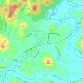
Name: Etowah topographic map, elevation, terrain.
Location: Etowah, Henderson County, North Carolina, United States (35.29686 -82.61836 35.34059 -82.57144)
Average elevation: 2,139 ft
Minimum elevation: 2,037 ft
Maximum elevation: 2,431 ft
Henderson County trails, hiking, mountain biking, running and outdoor activities
Make a donation
Gear up for your next adventure:
As an Amazon Associate, this site earns from qualifying purchases at no extra cost to you.
Other topographic maps
Click on a map to view its topography, its elevation and its terrain.
Hoopers Creek
United States > North Carolina > Henderson County > Fletcher
Average elevation: 2,221 ft
Make a donation
Gear up for your next adventure:
As an Amazon Associate, this site earns from qualifying purchases at no extra cost to you.
Edneyville
United States > North Carolina > Henderson County
Edneyville is in northeastern Henderson County at an elevation of 2,246 feet (685 m) above sea level. The Eastern Continental Divide runs through the center of the CDP; the eastern side of the community drains via Reedypatch Creek to the Broad River, which flows through the Congaree and Santee River systems to…
Average elevation: 2,260 ft
Make a donation
Gear up for your next adventure:
As an Amazon Associate, this site earns from qualifying purchases at no extra cost to you.
Chanteloupe Country Estates
United States > North Carolina > Henderson County > Flat Rock
Average elevation: 2,165 ft
Hendersonville Reservoir
United States > North Carolina > Henderson County
Average elevation: 2,805 ft
Make a donation
Gear up for your next adventure:
As an Amazon Associate, this site earns from qualifying purchases at no extra cost to you.
Mills River
United States > North Carolina > Henderson County > Mills River
Average elevation: 2,251 ft
Make a donation
Gear up for your next adventure:
As an Amazon Associate, this site earns from qualifying purchases at no extra cost to you.
Hoopers Creek
United States > North Carolina > Henderson County > Fletcher
Average elevation: 2,221 ft
Make a donation
Gear up for your next adventure:
As an Amazon Associate, this site earns from qualifying purchases at no extra cost to you.
Claremont
United States > North Carolina > Henderson County > Flat Rock > Claremont
Average elevation: 2,339 ft
Mills River
United States > North Carolina > Henderson County > Mills River > Oak Hill Court
Average elevation: 2,113 ft
Make a donation
Gear up for your next adventure:
As an Amazon Associate, this site earns from qualifying purchases at no extra cost to you.
Flat Rock Forest
United States > North Carolina > Henderson County > Flat Rock > Flat Rock Forest
Average elevation: 2,234 ft