Geolocate

Cyberjaya topographic map

Click on the map to display elevation.

About this map

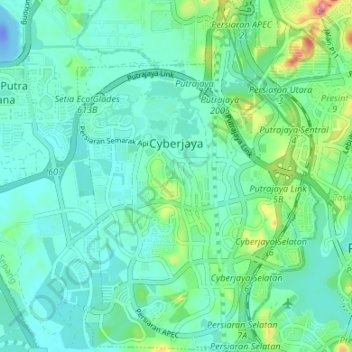
Name: Cyberjaya topographic map, elevation, terrain.

Location: Cyberjaya, Sepang, Selangor, Malaysia (2.89396 101.62666 2.96073 101.67478)

Average elevation: 79 ft

Minimum elevation: -118 ft

Maximum elevation: 364 ft

Other topographic maps

Click on a map to view its topography, its elevation and its terrain.

Kampung Labu Lanjut

Malaysia > Selangor > Sepang

Average elevation: 56 ft

Sungai Air Hitam

Malaysia > Selangor > Sepang

Average elevation: 10 ft

Gear up for your next adventure:

🧦Merino Wool Socks - Moisture-wicking, blister-preventing socks for long treks
📷Action Camera - Capture your outdoor adventures in HD
Backpacking Tents - Weight-optimized shelters for multi-day topographic surveys
🦺Reflective Outdoor Gear - Safety gear for low‑light conditions
💧Water Filtration Bottles - Safely drink from streams and lakes while exploring

As an Amazon Associate, this site earns from qualifying purchases at no extra cost to you.