
Make a donation
Gear up for your next adventure:
As an Amazon Associate, this site earns from qualifying purchases at no extra cost to you.
Bethany topographic map
Click on the map to display elevation.
Make a donation
Gear up for your next adventure:
As an Amazon Associate, this site earns from qualifying purchases at no extra cost to you.
About this map
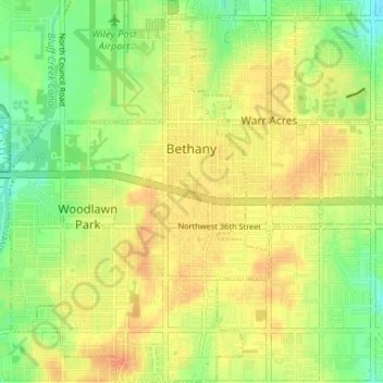
Name: Bethany topographic map, elevation, terrain.
Location: Bethany, Oklahoma County, Oklahoma, United States (35.48603 -97.66345 35.53932 -97.61897)
Average elevation: 1,299 ft
Minimum elevation: 1,230 ft
Maximum elevation: 1,352 ft
Oklahoma County trails, hiking, mountain biking, running and outdoor activities
Make a donation
Gear up for your next adventure:
As an Amazon Associate, this site earns from qualifying purchases at no extra cost to you.
Other topographic maps
Click on a map to view its topography, its elevation and its terrain.
Will Rogers Park
United States > Oklahoma > Oklahoma County > Oklahoma City
Average elevation: 1,247 ft
Newalla
United States > Oklahoma > Oklahoma County > Oklahoma City
Newalla, with a current elevation of 1,148 feet, is located within the Eastern bounds of Oklahoma County and appears on the Harrah, Oklahoma U.S. Geological Survey Map due to their proximity. Newalla is a geographic area which spans unincorporated Oklahoma County and unincorporated Cleveland County (also…
Average elevation: 1,125 ft
Make a donation
Gear up for your next adventure:
As an Amazon Associate, this site earns from qualifying purchases at no extra cost to you.
Lightning Creek Holding Pond B Dam
United States > Oklahoma > Oklahoma County > Oklahoma City
Average elevation: 1,266 ft
Make a donation
Gear up for your next adventure:
As an Amazon Associate, this site earns from qualifying purchases at no extra cost to you.