Geolocate

Pullontown topographic map

Click on the map to display elevation.

About this map

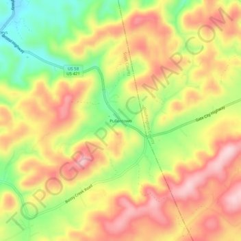
Name: Pullontown topographic map, elevation, terrain.

Location: Pullontown, Scott County, Virginia, United States (36.60233 -82.33320 36.64233 -82.29320)

Average elevation: 1,923 ft

Minimum elevation: 1,480 ft

Maximum elevation: 2,280 ft

Scott County trails, hiking, mountain biking, running and outdoor activities

Other topographic maps

Click on a map to view its topography, its elevation and its terrain.

Duffield

United States > Virginia > Scott County

Average elevation: 1,499 ft

Duffield

United States > Virginia > Scott County

Average elevation: 1,499 ft

Gate City

United States > Virginia > Scott County

Average elevation: 1,601 ft

Gear up for your next adventure:

🎒Outdoor Daypacks - Lightweight backpacks designed for carrying maps and essential gear
🕶️Glacier Sunglasses - Side shields to protect eyes from high-altitude snow glare
📌Outdoor GPS Map App - Apps and devices for digital topographic navigation
🎒Day Hiking Backpack - Lightweight backpack perfect for day trips and outdoor adventures
Solar GPS Watches - Advanced multisport watches with built-in topographic maps

As an Amazon Associate, this site earns from qualifying purchases at no extra cost to you.