Geolocate

West Mersea topographic map

Click on the map to display elevation.

About this map

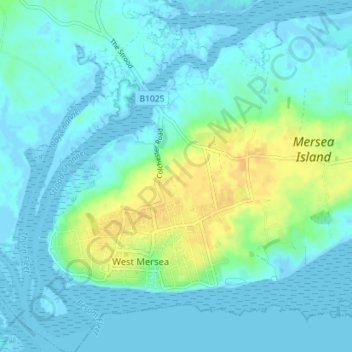
Name: West Mersea topographic map, elevation, terrain.

Location: West Mersea, Colchester, Essex, England, United Kingdom (51.76571 0.89370 51.80951 0.95639)

Average elevation: 20 ft

Minimum elevation: -10 ft

Maximum elevation: 75 ft

Other topographic maps

Click on a map to view its topography, its elevation and its terrain.

Berechurch

United Kingdom > England > Essex > Colchester

Average elevation: 92 ft

Layer-de-la-Haye

United Kingdom > England > Essex > Colchester

Average elevation: 95 ft

Wivenhoe Woods

United Kingdom > England > Essex > Colchester > Wivenhoe > Rowhedge

Average elevation: 59 ft

Boxted Cross

United Kingdom > England > Essex > Colchester > Boxted

Average elevation: 125 ft

Rowhedge

United Kingdom > England > Essex > Colchester

Average elevation: 66 ft

Birch Green

United Kingdom > England > Essex > Colchester

Average elevation: 115 ft

Messing

United Kingdom > England > Essex > Colchester

Average elevation: 148 ft

Salcott

United Kingdom > England > Essex > Colchester > Salcott

Average elevation: 46 ft

Horkesley Heath

United Kingdom > England > Essex > Colchester

Average elevation: 164 ft

Dedham Vale

United Kingdom > England > Essex > Colchester > Dedham

Average elevation: 49 ft

Inworth

United Kingdom > England > Essex > Colchester

Average elevation: 151 ft

Gear up for your next adventure:

Backpacking Tents - Weight-optimized shelters for multi-day topographic surveys
💧Water Purification System - Clean water on the trail with reliable purifiers
🪶Trail Camera - Capture wildlife on your hikes
🥾Women's Hiking Boots - Top-rated trail boots with ankle support and superior grip
🧭Orienteering Set - Complete compass and map reading kit

As an Amazon Associate, this site earns from qualifying purchases at no extra cost to you.