
Isle Forest topographic map
Click on the map to display elevation.
About this map
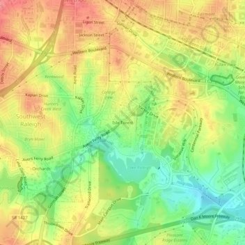
Name: Isle Forest topographic map, elevation, terrain.
Average elevation: 371 ft
Minimum elevation: 233 ft
Maximum elevation: 489 ft
Other topographic maps
Click on a map to view its topography, its elevation and its terrain.
William B. Umstead State Park
United States > North Carolina > Wake County > Raleigh
Umstead is part of the Southeastern mixed forests ecoregion. The topography is hilly, and it has several artificial lakes (which are very common in Wake County, partially due to a flood control plan implemented over the last half-century).
Average elevation: 381 ft
Lake Johnson
United States > North Carolina > Wake County > Raleigh > Orchards
Average elevation: 397 ft
Lake Raleigh
United States > North Carolina > Wake County > Raleigh > Isle Forest
Average elevation: 341 ft