Geolocate

Soras topographic map

Click on the map to display elevation.

About this map

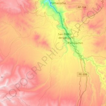
Name: Soras topographic map, elevation, terrain.

Location: Soras, Province of Sucre, Ayacucho, Peru (-14.35073 -73.82312 -14.07652 -73.57773)

Average elevation: 12,802 ft

Minimum elevation: 8,934 ft

Maximum elevation: 15,725 ft

Other topographic maps

Click on a map to view its topography, its elevation and its terrain.

Atacocha

Peru > Ayacucho

Average elevation: 10,581 ft

Mejorada

Peru > Ayacucho > Unión Progreso

Average elevation: 3,885 ft

Palmadera

Peru > Ayacucho

Average elevation: 12,231 ft

Guitarrayoc

Peru > Ayacucho > Uspa

Average elevation: 4,974 ft

Santa Rosa

Peru > Ayacucho > San Juan Bautista

Average elevation: 9,160 ft

Guitarrayoc

Peru > Ayacucho > Uspa

Average elevation: 4,974 ft

Unya

Peru > Ayacucho

Average elevation: 9,603 ft

Pampas

Peru > Ayacucho > Luis Carranza

Average elevation: 10,062 ft

Cancha Cancha

Peru > Ayacucho

Average elevation: 11,050 ft

Tambobamba

Peru > Ayacucho

Average elevation: 9,724 ft

La Vega

Peru > Ayacucho

Average elevation: 9,459 ft

Santa Fe

Peru > Ayacucho

Average elevation: 14,836 ft

Apachita

Peru > Ayacucho > Vilcas Huamán > Alto Perú > Apachita

Average elevation: 11,483 ft

Villa Virgen

Peru > Ayacucho > Llochegua

Average elevation: 2,060 ft

Gear up for your next adventure:

🪶LED Camping Lantern - Bright lantern for camp lighting
🪶Compact Camp Shovel - Folding shovel for campsite tasks
🧯Emergency Survival Kit - All‑in‑one survival essentials for the backcountry
🪓Survival Multi‑Tool - Versatile tool for camp and trail tasks
💧Water Purification System - Clean water on the trail with reliable purifiers

As an Amazon Associate, this site earns from qualifying purchases at no extra cost to you.