Geolocate

Tuy topographic map

Click on the map to display elevation.

About this map

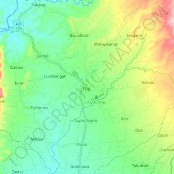
Name: Tuy topographic map, elevation, terrain.

Location: Tuy, Batangas, Calabarzon, 4214, Philippines (13.97950 120.69043 14.05950 120.77043)

Average elevation: 279 ft

Minimum elevation: 56 ft

Maximum elevation: 738 ft

Other topographic maps

Click on a map to view its topography, its elevation and its terrain.

Luna

Philippines > Batangas > Tuy

Average elevation: 246 ft

Palico River

Philippines > Batangas > Tuy > Sabang > Palico

Average elevation: 131 ft

Gear up for your next adventure:

🥇GPS Hiking Watch - Multi‑sport GPS watch with navigation and trail tracking
📶Satellite Messenger - Communication device off‑grid
📦Gear Storage Bags - Organize and protect outdoor equipment
📷Action Cameras - Rugged cameras to document your journeys across rugged terrain
🎒Day Hiking Backpack - Lightweight backpack perfect for day trips and outdoor adventures

As an Amazon Associate, this site earns from qualifying purchases at no extra cost to you.