Geolocate

Clonakilty topographic map

Click on the map to display elevation.

About this map

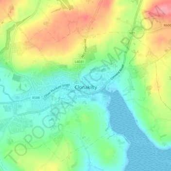
Name: Clonakilty topographic map, elevation, terrain.

Location: Clonakilty, County Cork, Munster, Ireland (51.61308 -8.91267 51.63321 -8.86753)

Average elevation: 135 ft

Minimum elevation: 0 ft

Maximum elevation: 354 ft

Other topographic maps

Click on a map to view its topography, its elevation and its terrain.

Model Village

Ireland > County Cork

Average elevation: 328 ft

Leamlara

Ireland > County Cork

Average elevation: 476 ft

Halfway

Ireland > County Cork

Average elevation: 315 ft

Minane Bridge

Ireland > County Cork

Average elevation: 230 ft

Macroom

Ireland > County Cork > Blarney - Macroom > Macroom

Average elevation: 377 ft

Lisgoold

Ireland > County Cork

Average elevation: 367 ft

Kilmichael

Ireland > County Cork

Average elevation: 436 ft

Mitchelstown

Ireland > County Cork > Mitchelstown

Average elevation: 417 ft

Lee Fields

Ireland > County Cork > Cork

Average elevation: 161 ft

Cobh

Ireland > County Cork > Cobh Municipal District > Cobh

Average elevation: 75 ft

Castletownbere

Ireland > County Cork > Castletownbere

Average elevation: 289 ft

Nad

Ireland > County Cork

Average elevation: 774 ft

Blarney

Ireland > County Cork > Blarney - Macroom > Blarney

Average elevation: 272 ft

Mount Gabriel

Ireland > County Cork

Average elevation: 564 ft

Gear up for your next adventure:

🦶Hiking Gaiters - Keep debris and water out of your boots
🔋Rechargeable Batteries - Power up your outdoor devices
🏔️Mountain Trail Maps - High‑detail maps for popular peaks
📡GPS Antenna Upgrade - Enhance GPS reception in remote terrain
📶Vehicle Signal Boosters - Improve reception in rural areas while driving to trailheads

As an Amazon Associate, this site earns from qualifying purchases at no extra cost to you.