Geolocate

Fermo topographic map

Click on the map to display elevation.

Fermo

Fermo is on a hill, the Sabulo, elevation 319 metres (1,047 ft), on a branch from Porto San Giorgio on the Adriatic coast railway.

Wikipedia (CC-BY-SA 3.0)

About this map

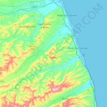
Name: Fermo topographic map, elevation, terrain.

Location: Fermo, Marche, 63900, Italy (43.10584 13.48920 43.23440 13.82928)

Average elevation: 322 ft

Minimum elevation: -7 ft

Maximum elevation: 1,506 ft

Other topographic maps

Click on a map to view its topography, its elevation and its terrain.

Monte Priora

Italy > Marche > Fermo > Montefortino

Average elevation: 5,932 ft

Coriconi

Italy > Marche > Fermo > Amandola

Average elevation: 1,657 ft

Gear up for your next adventure:

🧴Hand Sanitizer - Keep hands clean while hiking
🧤Hiking Gloves - Protective gloves for rugged trails
📖Nature Tracking Books - Learn to track wildlife and terrain
🪶Camp Gear Gift Set - Perfect gift bundle for outdoor fans
🥄Camping Utensil Set - Lightweight utensils for outdoor meals

As an Amazon Associate, this site earns from qualifying purchases at no extra cost to you.