Geolocate

Tolar topographic map

Click on the map to display elevation.

About this map

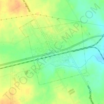
Name: Tolar topographic map, elevation, terrain.

Location: Tolar, Hood County, Texas, United States (32.38065 -97.93071 32.39778 -97.90988)

Average elevation: 1,040 ft

Minimum elevation: 984 ft

Maximum elevation: 1,096 ft

Hood County trails, hiking, mountain biking, running and outdoor activities

Other topographic maps

Click on a map to view its topography, its elevation and its terrain.

Paluxy

United States > Texas > Hood County

Average elevation: 833 ft

Acton

United States > Texas > Hood County

Average elevation: 797 ft

Pecan Plantation

United States > Texas > Hood County

Average elevation: 702 ft

Cresson

United States > Texas > Hood County

Average elevation: 994 ft

Oak Trail Shores

United States > Texas > Hood County

Average elevation: 758 ft

Gear up for your next adventure:

🪓Survival Multi‑Tool - Versatile tool for camp and trail tasks
📻Weather Alert Radios - Stay informed of storm risks while off-the-grid
🔥Fast-Boil Camping Stoves - Efficient cooking systems for quick trail meals
🎁Geography Themed Gifts - Unique gift ideas for map lovers and geography enthusiasts
🧭Outdoor Navigation Book - Learn advanced navigation skills

As an Amazon Associate, this site earns from qualifying purchases at no extra cost to you.