Geolocate

Acton topographic map

Click on the map to display elevation.

About this map

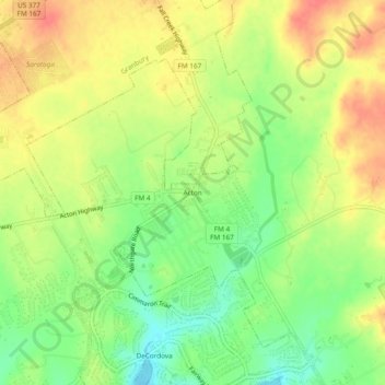
Name: Acton topographic map, elevation, terrain.

Location: Acton, Hood County, Texas, 76049, United States (32.42681 -97.71030 32.46681 -97.67030)

Average elevation: 797 ft

Minimum elevation: 696 ft

Maximum elevation: 889 ft

Hood County trails, hiking, mountain biking, running and outdoor activities

Other topographic maps

Click on a map to view its topography, its elevation and its terrain.

Lipan

United States > Texas > Hood County

Average elevation: 922 ft

Tolar

United States > Texas > Hood County

Average elevation: 1,040 ft

Lake Granbury

United States > Texas > Hood County > Brazos Bend

Average elevation: 817 ft

Cresson

United States > Texas > Hood County

Average elevation: 994 ft

DeCordova

United States > Texas > Hood County

Average elevation: 735 ft

Brazos Bend

United States > Texas > Hood County

Average elevation: 745 ft

Gear up for your next adventure:

💧Water Purification System - Clean water on the trail with reliable purifiers
🪑Ultralight Camp Chairs - Portable seating for resting after a long day of mapping
🍳Camping Cook Set - Complete cookware for outdoor meals
🧤Hiking Gloves - Protective gloves for rugged trails
📡GPS Antenna Upgrade - Enhance GPS reception in remote terrain

As an Amazon Associate, this site earns from qualifying purchases at no extra cost to you.