Geolocate

Catandala topographic map

Click on the map to display elevation.

About this map

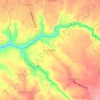
Name: Catandala topographic map, elevation, terrain.

Location: Catandala, Ibaan, Batangas, Calabarzon, 4230, Philippines (13.76973 121.12895 13.80973 121.16895)

Average elevation: 312 ft

Minimum elevation: 46 ft

Maximum elevation: 456 ft

Other topographic maps

Click on a map to view its topography, its elevation and its terrain.

Pangao

Philippines > Batangas > Ibaan

Average elevation: 427 ft

Calumpang River

Philippines > Batangas > Ibaan > Catandala

Average elevation: 305 ft

Calumpang River

Philippines > Batangas > Ibaan > Balanga

Average elevation: 276 ft

Calumpang River

Philippines > Batangas > Ibaan

Average elevation: 325 ft

Coliat

Philippines > Batangas > Ibaan

Average elevation: 371 ft

Talaibon

Philippines > Batangas > Ibaan

Average elevation: 466 ft

Pangao

Philippines > Batangas > Ibaan

Average elevation: 427 ft

Taysan River

Philippines > Batangas > Ibaan > Salaban Ⅱ

Average elevation: 456 ft

Palindan

Philippines > Batangas > Ibaan

Average elevation: 440 ft

Balanga

Philippines > Batangas > Ibaan

Average elevation: 305 ft

Gear up for your next adventure:

🥾Hiking Shoes - Durable and comfortable shoes for trail hiking
👓Polarized Sunglasses - Outdoor sunglasses for glare reduction
🔌USB Car Charger - Car charger for on‑the‑go power needs
🥾Women's Hiking Boots - Top-rated trail boots with ankle support and superior grip
🧢Sun Protection Hats - Wide-brimmed and UPF-rated hats for high-altitude sun safety

As an Amazon Associate, this site earns from qualifying purchases at no extra cost to you.