
Make a donation
Gear up for your next adventure:
As an Amazon Associate, this site earns from qualifying purchases at no extra cost to you.
Jardim Camburi topographic map
Click on the map to display elevation.
Make a donation
Gear up for your next adventure:
As an Amazon Associate, this site earns from qualifying purchases at no extra cost to you.
About this map
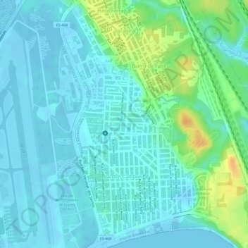
Name: Jardim Camburi topographic map, elevation, terrain.
Average elevation: 30 ft
Minimum elevation: -10 ft
Maximum elevation: 118 ft
Make a donation
Gear up for your next adventure:
As an Amazon Associate, this site earns from qualifying purchases at no extra cost to you.
Other topographic maps
Click on a map to view its topography, its elevation and its terrain.
Vitória
Brasil > Espírito Santo > Região Metropolitana da Grande Vitória > Vitória
O relevo das ilhas é um prolongamento do continente, de constituição granítica, circundado pelo mar e áreas de mangue e restinga. O maciço central da ilha de Vitória, o Morro da Fonte Grande, possui altitude de 308,8 metros. Os principais afloramentos graníticos são a Pedra dos Dois Olhos, com 296…
Average elevation: 141 ft
Morro do Paul
Brasil > Espírito Santo > Região Metropolitana da Grande Vitória > Vitória
Average elevation: 102 ft
Morro da Fonte Grande
Brasil > Espírito Santo > Região Metropolitana da Grande Vitória > Vitória
Average elevation: 282 ft
Praça do Papa
Brasil > Espírito Santo > Região Metropolitana da Grande Vitória > Vitória
Average elevation: 36 ft
Make a donation
Gear up for your next adventure:
As an Amazon Associate, this site earns from qualifying purchases at no extra cost to you.
Ilha do Boi
Brasil > Espírito Santo > Região Metropolitana da Grande Vitória > Vitória
Average elevation: 305 ft