
Make a donation
Gear up for your next adventure:
As an Amazon Associate, this site earns from qualifying purchases at no extra cost to you.
Morro do Paul topographic map
Click on the map to display elevation.
Make a donation
Gear up for your next adventure:
As an Amazon Associate, this site earns from qualifying purchases at no extra cost to you.
About this map
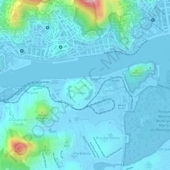
Name: Morro do Paul topographic map, elevation, terrain.
Average elevation: 102 ft
Minimum elevation: -20 ft
Maximum elevation: 863 ft
Make a donation
Gear up for your next adventure:
As an Amazon Associate, this site earns from qualifying purchases at no extra cost to you.
Other topographic maps
Click on a map to view its topography, its elevation and its terrain.
Grande Vitória
Brasil > Espírito Santo > Região Metropolitana da Grande Vitória > Vitória
Average elevation: 131 ft
Jardim da Penha
Brasil > Espírito Santo > Região Metropolitana da Grande Vitória > Vitória
Average elevation: 13 ft
São Benedito
Brasil > Espírito Santo > Região Metropolitana da Grande Vitória > Vitória
Average elevation: 49 ft
Boa Vista
Brasil > Espírito Santo > Região Metropolitana da Grande Vitória > Vitória
Average elevation: 10 ft
Make a donation
Gear up for your next adventure:
As an Amazon Associate, this site earns from qualifying purchases at no extra cost to you.
Praia do Canto
Brasil > Espírito Santo > Região Metropolitana da Grande Vitória > Vitória
Average elevation: 30 ft
Santo Antônio
Brasil > Espírito Santo > Região Metropolitana da Grande Vitória > Vitória
Average elevation: 92 ft
Pontal de Camburi
Brasil > Espírito Santo > Região Metropolitana da Grande Vitória > Vitória
Average elevation: 26 ft
Goiabeiras
Brasil > Espírito Santo > Região Metropolitana da Grande Vitória > Vitória
Average elevation: 10 ft
Make a donation
Gear up for your next adventure:
As an Amazon Associate, this site earns from qualifying purchases at no extra cost to you.
Vila Rubim
Brasil > Espírito Santo > Região Metropolitana da Grande Vitória > Vitória
Average elevation: 138 ft
Vitória
Brasil > Espírito Santo > Região Metropolitana da Grande Vitória > Vitória
Average elevation: 59 ft
Jardim Camburi
Brasil > Espírito Santo > Região Metropolitana da Grande Vitória > Vitória
Average elevation: 30 ft
Baía do Espírito Santo
Brasil > Espírito Santo > Região Metropolitana da Grande Vitória > Vitória
Average elevation: 7 ft
Make a donation
Gear up for your next adventure:
As an Amazon Associate, this site earns from qualifying purchases at no extra cost to you.
Parque Estadual da Fonte Grande
Brasil > Espírito Santo > Região Metropolitana da Grande Vitória > Vitória
O parque é a última área contígua de grande porte com vegetação característica de encostas da Mata Atlântica. A topografia é acidentada, com relevo ondulado, incluindo vales e pontões.
Average elevation: 299 ft
Praia de Camburi
Brasil > Espírito Santo > Região Metropolitana da Grande Vitória > Vitória
Average elevation: 13 ft
República
Brasil > Espírito Santo > Região Metropolitana da Grande Vitória > Vitória
Average elevation: 10 ft
Barro Vermelho
Brasil > Espírito Santo > Região Metropolitana da Grande Vitória > Vitória
Average elevation: 36 ft
Make a donation
Gear up for your next adventure:
As an Amazon Associate, this site earns from qualifying purchases at no extra cost to you.
Santa Tereza
Brasil > Espírito Santo > Região Metropolitana da Grande Vitória > Vitória
Average elevation: 174 ft
Ilha do Frade
Brasil > Espírito Santo > Região Metropolitana da Grande Vitória > Vitória
Average elevation: 10 ft
Praça do Papa
Brasil > Espírito Santo > Região Metropolitana da Grande Vitória > Vitória
Average elevation: 36 ft
Ilha das Caieiras
Brasil > Espírito Santo > Região Metropolitana da Grande Vitória > Vitória
Average elevation: 62 ft
Make a donation
Gear up for your next adventure:
As an Amazon Associate, this site earns from qualifying purchases at no extra cost to you.
Fonte Grande
Brasil > Espírito Santo > Região Metropolitana da Grande Vitória > Vitória
Average elevation: 236 ft