Geolocate

Periya topographic map

Interactive map

Click on the map to display elevation.

About this map

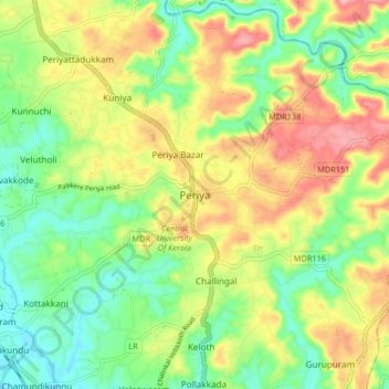
Name: Periya topographic map, elevation, terrain.

Location: Periya, Hosdurg, Kasaragod District, Kerala, 671320, India (12.36164 75.05729 12.44164 75.13729)

Average elevation: 197 ft

Minimum elevation: 10 ft

Maximum elevation: 446 ft

Other topographic maps

Click on a map to view its topography, its elevation and its terrain.

Beericheri

India > Kerala > Hosdurg

Beericheri, Hosdurg, Kasaragod District, Kerala, 671311, India

Average elevation: 23 ft

Thadiyankovval

India > Kerala > Hosdurg > Thrikaripur

Thadiyankovval, Thrikaripur, Hosdurg, Kasaragod District, Kerala, India

Average elevation: 30 ft

Thrikaripur

India > Kerala > Hosdurg

Thrikaripur, Hosdurg, Kasaragod district, Kerala, 671349, India

Average elevation: 23 ft

Udma

India > Kerala > Hosdurg > Uduma

Udma, Uduma, Hosdurg, Kasaragod district, Kerala, India

Average elevation: 85 ft

Punathil

India > Kerala > Hosdurg > Punathil

Punathil, Hosdurg, Kasaragod district, Kerala, 671350, India

Average elevation: 16 ft