
罗镜镇 topographic map
Interactive map
Click on the map to display elevation.
About this map
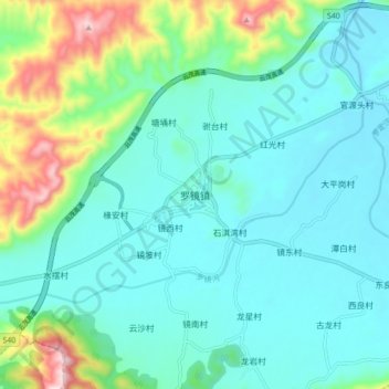
Name: 罗镜镇 topographic map, elevation, terrain.
Location: 罗镜镇, 罗定市, 云浮市, 广东省, 中国 (22.50731 111.39791 22.58731 111.47791)
Average elevation: 568 ft
Minimum elevation: 266 ft
Maximum elevation: 1,703 ft
Other topographic maps
Click on a map to view its topography, its elevation and its terrain.