Geolocate

Greer topographic map

Click on the map to display elevation.

About this map

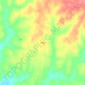
Name: Greer topographic map, elevation, terrain.

Location: Greer, Elmore County, Alabama, United States (32.66069 -86.17691 32.70069 -86.13691)

Average elevation: 492 ft

Minimum elevation: 351 ft

Maximum elevation: 627 ft

Elmore County trails, hiking, mountain biking, running and outdoor activities

Other topographic maps

Click on a map to view its topography, its elevation and its terrain.

Blue Ridge

United States > Alabama > Elmore County

Average elevation: 289 ft

Gear up for your next adventure:

🏕️Tent Footprint - Protect your tent base from wear
⛑️Personal Locator Beacon - Safety beacon for emergencies
🥘Titanium Cookware - Durable, featherlight pots and pans for backpacking
🧯Emergency Survival Kit - All‑in‑one survival essentials for the backcountry
🛰️Handheld GPS Units - Professional satellite navigators for precise backcountry mapping

As an Amazon Associate, this site earns from qualifying purchases at no extra cost to you.