Geolocate

Blue Ridge topographic map

Click on the map to display elevation.

About this map

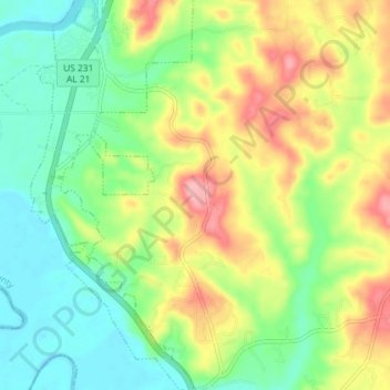
Name: Blue Ridge topographic map, elevation, terrain.

Location: Blue Ridge, Elmore County, Alabama, United States (32.46914 -86.21600 32.53016 -86.15728)

Average elevation: 289 ft

Minimum elevation: 128 ft

Maximum elevation: 538 ft

Elmore County trails, hiking, mountain biking, running and outdoor activities

Other topographic maps

Click on a map to view its topography, its elevation and its terrain.

Old Bingham

United States > Alabama > Elmore County

Average elevation: 203 ft

Greer

United States > Alabama > Elmore County

Average elevation: 492 ft

Red Hill

United States > Alabama > Elmore County

Average elevation: 525 ft

Ware

United States > Alabama > Elmore County > Ware

Average elevation: 348 ft

Jasmine Hill

United States > Alabama > Elmore County > Jasmine Hill

Average elevation: 318 ft

Gear up for your next adventure:

📚Navigation Handbooks - Master the art of reading topographic maps and using a compass
👟Trail Running Shoes - Lightweight shoes for trail runners
🪑Portable Camp Table - Compact table for campsite meals
📌Outdoor GPS Map App - Apps and devices for digital topographic navigation
🦺Reflective Outdoor Gear - Safety gear for low‑light conditions

As an Amazon Associate, this site earns from qualifying purchases at no extra cost to you.