
Thank you for supporting this site ❤️
Make a donation
Make a donation
Gear up for your next adventure:
As an Amazon Associate, this site earns from qualifying purchases at no extra cost to you.
Melbou topographic map
Click on the map to display elevation.
Thank you for supporting this site ❤️
Make a donation
Make a donation
Gear up for your next adventure:
As an Amazon Associate, this site earns from qualifying purchases at no extra cost to you.
About this map
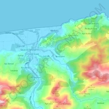
Name: Melbou topographic map, elevation, terrain.
Location: Melbou, Souk El-Tenine District, Bejaia, 06012, Algeria (36.58357 5.33038 36.65913 5.43795)
Average elevation: 801 ft
Minimum elevation: -7 ft
Maximum elevation: 3,386 ft
Thank you for supporting this site ❤️
Make a donation
Make a donation
Gear up for your next adventure:
As an Amazon Associate, this site earns from qualifying purchases at no extra cost to you.
Other topographic maps
Click on a map to view its topography, its elevation and its terrain.
Chta
Algeria > Bejaia > Souk El-Tenine District > Souk El Tenine > Louta > Chta
Average elevation: 594 ft