Geolocate

Balagbag topographic map

Click on the map to display elevation.

About this map

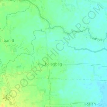
Name: Balagbag topographic map, elevation, terrain.

Location: Balagbag, San Juan, Batangas, Calabarzon, Philippines (13.79865 121.40389 13.81387 121.43451)

Average elevation: 33 ft

Minimum elevation: 7 ft

Maximum elevation: 75 ft

Other topographic maps

Click on a map to view its topography, its elevation and its terrain.

Malaking Tubig River

Philippines > Batangas > San Juan

Average elevation: 33 ft

Ticalan

Philippines > Batangas > San Juan > Ticalan

Average elevation: 26 ft

Hugom

Philippines > Batangas > San Juan > Hugom

Average elevation: 249 ft

Gear up for your next adventure:

🔦LED Headlamp - Bright and durable LED headlamp for night navigation
🛌Ultralight Sleeping Bags - Compact down bags for cold nights in the wilderness
📷Action Cameras - Rugged cameras to document your journeys across rugged terrain
🎁Geography Themed Gifts - Unique gift ideas for map lovers and geography enthusiasts
📡GPS Antenna Upgrade - Enhance GPS reception in remote terrain

As an Amazon Associate, this site earns from qualifying purchases at no extra cost to you.