Geolocate

Crystal Springs topographic map

Click on the map to display elevation.

About this map

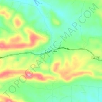
Name: Crystal Springs topographic map, elevation, terrain.

Location: Crystal Springs, Garland County, Arkansas, United States (34.50204 -93.35602 34.54204 -93.31602)

Average elevation: 745 ft

Minimum elevation: 577 ft

Maximum elevation: 994 ft

Garland County trails, hiking, mountain biking, running and outdoor activities

Other topographic maps

Click on a map to view its topography, its elevation and its terrain.

Mountain Pine

United States > Arkansas > Garland County

Average elevation: 522 ft

Rockwell

United States > Arkansas > Garland County > Rockwell

Average elevation: 453 ft

Piney

United States > Arkansas > Garland County > Hot Springs

Average elevation: 479 ft

Lonsdale

United States > Arkansas > Garland County

Average elevation: 489 ft

Gear up for your next adventure:

🩳Quick‑Dry Hiking Shorts - Comfortable and quick‑dry shorts for summer hiking
🪶Survival Guide Book - Expert advice for emergency preparedness
🌄Hiking Binoculars - Compact binoculars for scenic views and trail spotting
⛑️Personal Locator Beacon - Safety beacon for emergencies
🛰️Handheld GPS Units - Professional satellite navigators for precise backcountry mapping

As an Amazon Associate, this site earns from qualifying purchases at no extra cost to you.