
Make a donation
Gear up for your next adventure:
As an Amazon Associate, this site earns from qualifying purchases at no extra cost to you.
Peñafiel topographic map
Click on the map to display elevation.
Make a donation
Gear up for your next adventure:
As an Amazon Associate, this site earns from qualifying purchases at no extra cost to you.
About this map
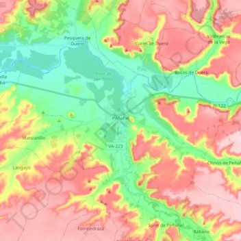
Name: Peñafiel topographic map, elevation, terrain.
Location: Peñafiel, Valladolid, Castile and León, 47300, Spain (41.54976 -4.22444 41.64233 -4.04123)
Average elevation: 2,703 ft
Minimum elevation: 2,395 ft
Maximum elevation: 3,028 ft
Make a donation
Gear up for your next adventure:
As an Amazon Associate, this site earns from qualifying purchases at no extra cost to you.
Other topographic maps
Click on a map to view its topography, its elevation and its terrain.
Make a donation
Gear up for your next adventure:
As an Amazon Associate, this site earns from qualifying purchases at no extra cost to you.
Presa Vieja de Las Navas del Marques
Spain > Castile and León > Peguerinos
Average elevation: 4,908 ft
Make a donation
Gear up for your next adventure:
As an Amazon Associate, this site earns from qualifying purchases at no extra cost to you.