Geolocate

Laurier topographic map

Click on the map to display elevation.

About this map

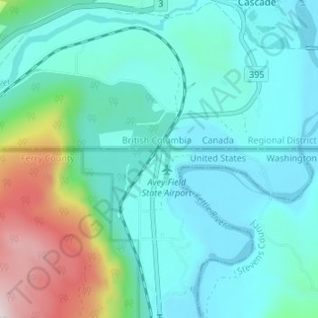
Name: Laurier topographic map, elevation, terrain.

Location: Laurier, Ferry County, Washington, 99146, United States (48.97879 -118.24418 49.01879 -118.20418)

Average elevation: 1,982 ft

Minimum elevation: 1,421 ft

Maximum elevation: 4,268 ft

Ferry County trails, hiking, mountain biking, running and outdoor activities

Other topographic maps

Click on a map to view its topography, its elevation and its terrain.

Inchelium

United States > Washington > Ferry County

Average elevation: 2,096 ft

Keller

United States > Washington > Ferry County > Keller

Average elevation: 2,218 ft

Ferry Lake

United States > Washington > Ferry County

Average elevation: 3,432 ft

Wiseman Island

United States > Washington > Ferry County > Pollard

Average elevation: 2,549 ft

Gear up for your next adventure:

🕶️GPS Smartphone Mount - Secure mount for phone navigation
🪶Fire Starter Kit - Reliable fire starter for survival and camping
🌧️Backpack Rain Cover - Keep gear dry in wet weather
📷Action Cameras - Rugged cameras to document your journeys across rugged terrain
📚USA Hiking Guide Books - Top trail guides and map books

As an Amazon Associate, this site earns from qualifying purchases at no extra cost to you.