
The Nublet topographic map
Click on the map to display elevation.
About this map
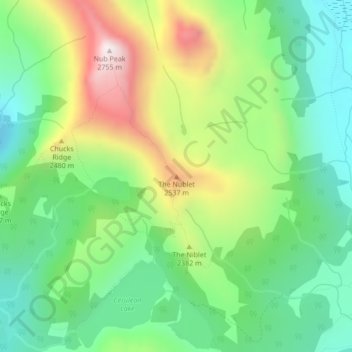
Name: The Nublet topographic map, elevation, terrain.
Average elevation: 7,549 ft
Minimum elevation: 6,739 ft
Maximum elevation: 8,986 ft
Other topographic maps
Click on a map to view its topography, its elevation and its terrain.
Baptiste Lake
Canada > British Columbia > Regional District of East Kootenay > Area G (Forster Creek/Mount Assiniboine)
Average elevation: 3,501 ft
Cobb Lake
Canada > British Columbia > Regional District of East Kootenay > Area G (Forster Creek/Mount Assiniboine)
Average elevation: 4,482 ft
Valley of the Rocks
Canada > British Columbia > Regional District of East Kootenay > Area G (Forster Creek/Mount Assiniboine)
Average elevation: 7,211 ft