Geolocate

Rhu topographic map

Click on the map to display elevation.

About this map

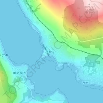
Name: Rhu topographic map, elevation, terrain.

Location: Rhu, Argyll and Bute, Scotland, G84 8RU, United Kingdom (55.99819 -4.79942 56.03819 -4.75942)

Average elevation: 220 ft

Minimum elevation: -3 ft

Maximum elevation: 1,142 ft

Other topographic maps

Click on a map to view its topography, its elevation and its terrain.

Tarbert

United Kingdom > Scotland > Argyll and Bute

Average elevation: 226 ft

Torsa

United Kingdom > Scotland > Argyll and Bute > Cuan > Silver Moon

Average elevation: 39 ft

Easdale

United Kingdom > Scotland > Argyll and Bute > Easdale

Average elevation: 26 ft

Texa

United Kingdom > Scotland > Argyll and Bute

Average elevation: 3 ft

Bute

United Kingdom > Scotland > Argyll and Bute > Townhead

Average elevation: 135 ft

Scarba

United Kingdom > Scotland > Argyll and Bute

Average elevation: 299 ft

Coll

United Kingdom > Scotland > Argyll and Bute > Arinagour

Average elevation: 23 ft

Ardrishaig

United Kingdom > Scotland > Argyll and Bute

Average elevation: 217 ft

Gear up for your next adventure:

🕶️Glacier Sunglasses - Side shields to protect eyes from high-altitude snow glare
🌎3D Topographic Globes - Raised relief globes for a tactile understanding of geography
🌡️Portable Weather Meter - Track weather conditions on the trail
🪶Compact Camp Shovel - Folding shovel for campsite tasks
🧥Men's Rain Shells - Premium waterproof and breathable jackets for mountain weather

As an Amazon Associate, this site earns from qualifying purchases at no extra cost to you.