
Madison topographic map
Click on the map to display elevation.
About this map
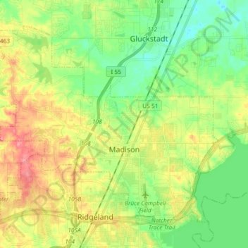
Name: Madison topographic map, elevation, terrain.
Location: Madison, Madison County, Mississippi, United States (32.42591 -90.20528 32.52270 -90.06031)
Average elevation: 328 ft
Minimum elevation: 230 ft
Maximum elevation: 469 ft
Madison County trails, hiking, mountain biking, running and outdoor activities
Other topographic maps
Click on a map to view its topography, its elevation and its terrain.
Traceland North
United States > Mississippi > Madison County > Madison > Traceland North
Average elevation: 335 ft