
Make a donation
Gear up for your next adventure:
As an Amazon Associate, this site earns from qualifying purchases at no extra cost to you.
Marsous topographic map
Click on the map to display elevation.
Make a donation
Gear up for your next adventure:
As an Amazon Associate, this site earns from qualifying purchases at no extra cost to you.
About this map
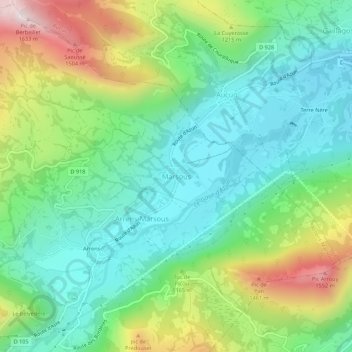
Name: Marsous topographic map, elevation, terrain.
Average elevation: 3,501 ft
Minimum elevation: 2,684 ft
Maximum elevation: 5,259 ft
Make a donation
Gear up for your next adventure:
As an Amazon Associate, this site earns from qualifying purchases at no extra cost to you.
Other topographic maps
Click on a map to view its topography, its elevation and its terrain.
Lourdes
France > Occitania > Hautes Pyrenees
Lourdes lies at an elevation of 420 m (1,380 ft) and in a central position through which runs the fast-flowing river Gave de Pau from the south, coming from its source at Gavarnie; into it flow several smaller rivers from Barèges and Cauterets. The Gave then branches off to the west towards the Béarn,…
Average elevation: 1,686 ft
Make a donation
Gear up for your next adventure:
As an Amazon Associate, this site earns from qualifying purchases at no extra cost to you.
Communauté de communes du Plateau de Lannemezan
France > Occitania > Hautes Pyrenees
Average elevation: 1,883 ft
Make a donation
Gear up for your next adventure:
As an Amazon Associate, this site earns from qualifying purchases at no extra cost to you.
Tarbes
France > Occitania > Hautes Pyrenees
Tarbes is a Pre-Pyrenees town within the rich agricultural plain of the river Adour, 155 kilometres (96 miles) southwest of Toulouse, 144 kilometres (89 miles) to the east of Bayonne, 70 kilometres (43 miles) southwest of Auch and 20 kilometres (12 miles) northeast of Lourdes. Tarbes is 1 hr 30 mins from the…
Average elevation: 1,010 ft
Make a donation
Gear up for your next adventure:
As an Amazon Associate, this site earns from qualifying purchases at no extra cost to you.
Cauterets
France > Occitania > Hautes Pyrenees
The minimum altitude, 503 metres (1,650 ft), is located in the north, where the Gave de Cauterets leaves the communal area and enters that of Soulom. The maximum elevation of 3,298 metres (10,820 ft) corresponds to the highest point of the French Pyrénées, Vignemale, marking the border with Spain [fr]. Other…
Average elevation: 5,961 ft
Make a donation
Gear up for your next adventure:
As an Amazon Associate, this site earns from qualifying purchases at no extra cost to you.
Make a donation
Gear up for your next adventure:
As an Amazon Associate, this site earns from qualifying purchases at no extra cost to you.
Lourdes
France > Occitania > Hautes Pyrenees
Lourdes lies at an elevation of 420 m (1,380 ft) and in a central position through which runs the fast-flowing river Gave de Pau from the south, coming from its source at Gavarnie; into it flow several smaller rivers from Barèges and Cauterets. The Gave then branches off to the west towards the Béarn,…
Average elevation: 1,686 ft
Make a donation
Gear up for your next adventure:
As an Amazon Associate, this site earns from qualifying purchases at no extra cost to you.
Make a donation
Gear up for your next adventure:
As an Amazon Associate, this site earns from qualifying purchases at no extra cost to you.
Cauterets
France > Occitania > Hautes Pyrenees
The minimum altitude, 503 metres (1,650 ft), is located in the north, where the Gave de Cauterets leaves the communal area and enters that of Soulom. The maximum elevation of 3,298 metres (10,820 ft) corresponds to the highest point of the French Pyrénées, Vignemale, marking the border with Spain (fr). Other…
Average elevation: 5,961 ft
Make a donation
Gear up for your next adventure:
As an Amazon Associate, this site earns from qualifying purchases at no extra cost to you.
Cirque de Gavarnie
France > Occitania > Hautes Pyrenees > Gavarnie-Gèdre > Gavarnie
Average elevation: 7,756 ft
Make a donation
Gear up for your next adventure:
As an Amazon Associate, this site earns from qualifying purchases at no extra cost to you.
Make a donation
Gear up for your next adventure:
As an Amazon Associate, this site earns from qualifying purchases at no extra cost to you.
Campan
France > Occitania > Hautes Pyrenees
The commune covers an area of 9,541 hectares; its altitude varies between 629 and 2,747 meters.
Average elevation: 5,276 ft
Make a donation
Gear up for your next adventure:
As an Amazon Associate, this site earns from qualifying purchases at no extra cost to you.
Maubourguet
France > Occitania > Hautes Pyrenees
The territory of Maubourguet extends over 22.04 km2; its elevation varies between 164 and 285 meters. The highest point of the commune is in the west, on the hills overlooking the plain of the Adour. The minimum elevation is at the level of the Adour when it leaves the territory in the north.
Average elevation: 610 ft
Make a donation
Gear up for your next adventure:
As an Amazon Associate, this site earns from qualifying purchases at no extra cost to you.
Lac de Gaube
France > Occitania > Hautes Pyrenees > Cauterets
The lake is situated in an altitude of 1725 m, an egg-shaped form stretching itself along a north–south axis in the valley of Gaube. This steep-sided valley is located at the foot of the Vignemale (3298M). The lake is surrounded by the peak Mayouret (2688 m) to the east, the big Peak of the Paloumères (2720…
Average elevation: 6,821 ft
Make a donation
Gear up for your next adventure:
As an Amazon Associate, this site earns from qualifying purchases at no extra cost to you.
Barèges
France > Occitania > Hautes Pyrenees
The town is bounded in the north-west by the Bastan river which flows from east to west in a narrow valley through the main village (at an altitude of 1250 m) and through its main inhabited areas. The Bastan forms the northern border of the commune with the commune of Sers.
Average elevation: 6,050 ft
Maubourguet
France > Occitania > Hautes Pyrenees
The territory of Maubourguet extends over 22.04 km2; its elevation varies between 164 and 285 meters. The highest point of the commune is in the west, on the hills overlooking the plain of the Adour. The minimum elevation is at the level of the Adour when it leaves the territory in the north.
Average elevation: 610 ft
Make a donation
Gear up for your next adventure:
As an Amazon Associate, this site earns from qualifying purchases at no extra cost to you.
Make a donation
Gear up for your next adventure:
As an Amazon Associate, this site earns from qualifying purchases at no extra cost to you.
Make a donation
Gear up for your next adventure:
As an Amazon Associate, this site earns from qualifying purchases at no extra cost to you.
Cirque de Gavarnie
France > Occitania > Hautes Pyrenees > Gavarnie-Gèdre > Gavarnie
Average elevation: 7,756 ft
Make a donation
Gear up for your next adventure:
As an Amazon Associate, this site earns from qualifying purchases at no extra cost to you.
Make a donation
Gear up for your next adventure:
As an Amazon Associate, this site earns from qualifying purchases at no extra cost to you.
Make a donation
Gear up for your next adventure:
As an Amazon Associate, this site earns from qualifying purchases at no extra cost to you.
Make a donation
Gear up for your next adventure:
As an Amazon Associate, this site earns from qualifying purchases at no extra cost to you.
Barèges
France > Occitania > Hautes Pyrenees
The town is bounded in the north-west by the Bastan river which flows from east to west in a narrow valley through the main village (at an altitude of 1250 m) and through its main inhabited areas. The Bastan forms the northern border of the commune with the commune of Sers.
Average elevation: 6,050 ft
Make a donation
Gear up for your next adventure:
As an Amazon Associate, this site earns from qualifying purchases at no extra cost to you.
Make a donation
Gear up for your next adventure:
As an Amazon Associate, this site earns from qualifying purchases at no extra cost to you.