
Whiteville topographic map
Interactive map
Click on the map to display elevation.
About this map
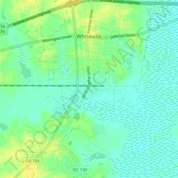
Name: Whiteville topographic map, elevation, terrain.
Average elevation: 72 ft
Minimum elevation: 46 ft
Maximum elevation: 115 ft
Other topographic maps
Click on a map to view its topography, its elevation and its terrain.
Evergreen
United States > North Carolina > Columbus County
Evergreen, Columbus County, North Carolina, 28436, United States
Average elevation: 49 ft
Nakina
United States > North Carolina > Columbus County
Nakina, Columbus County, North Carolina, 28455, United States
Average elevation: 52 ft
Lake Waccamaw
United States > North Carolina > Columbus County
Lake Waccamaw, Columbus County, North Carolina, United States
Average elevation: 49 ft
Fair Bluff
United States > North Carolina > Columbus County
Fair Bluff, Columbus County, North Carolina, United States
Average elevation: 69 ft
Waccamaw River
United States > North Carolina > Columbus County
Waccamaw River, Columbus County, North Carolina, United States
Average elevation: 43 ft
Pine Level
United States > North Carolina > Columbus County > Pine Level
Pine Level, Columbus County, North Carolina, 28455, United States
Average elevation: 49 ft
Tabor City
United States > North Carolina > Columbus County > Tabor City
Tabor City, Columbus County, North Carolina, United States
Average elevation: 98 ft
Delco
United States > North Carolina > Columbus County
Delco, Columbus County, North Carolina, 28436, United States
Average elevation: 36 ft