
Make a donation
Gear up for your next adventure:
As an Amazon Associate, this site earns from qualifying purchases at no extra cost to you.
Manassas Gap topographic map
Click on the map to display elevation.
Make a donation
Gear up for your next adventure:
As an Amazon Associate, this site earns from qualifying purchases at no extra cost to you.
Manassas Gap
Manassas Gap is a wind gap of the Blue Ridge Mountains on the border of Fauquier County and Warren County in Virginia. At an elevation of 887 feet above sea level, it is the lowest crossing of the Blue Ridge Mountains in the state. "The origins of the name "Manassas" are undocumented."
Make a donation
Gear up for your next adventure:
As an Amazon Associate, this site earns from qualifying purchases at no extra cost to you.
About this map
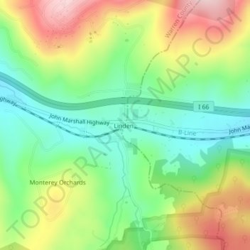
Name: Manassas Gap topographic map, elevation, terrain.
Average elevation: 1,145 ft
Minimum elevation: 814 ft
Maximum elevation: 1,634 ft
Fauquier County trails, hiking, mountain biking, running and outdoor activities
Make a donation
Gear up for your next adventure:
As an Amazon Associate, this site earns from qualifying purchases at no extra cost to you.
Other topographic maps
Click on a map to view its topography, its elevation and its terrain.
Make a donation
Gear up for your next adventure:
As an Amazon Associate, this site earns from qualifying purchases at no extra cost to you.
C.F. Phelps Wildlife Management Area
United States > Virginia > Fauquier County
Average elevation: 312 ft
Make a donation
Gear up for your next adventure:
As an Amazon Associate, this site earns from qualifying purchases at no extra cost to you.