Geolocate

Ward topographic map

Click on the map to display elevation.

About this map

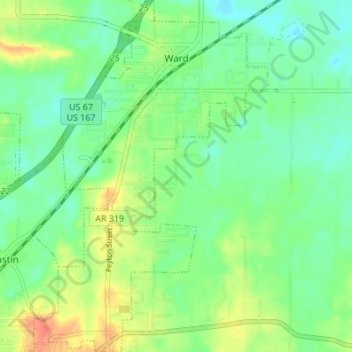
Name: Ward topographic map, elevation, terrain.

Location: Ward, Lonoke County, Arkansas, 72007, United States (34.98376 -91.97620 35.03955 -91.93276)

Average elevation: 249 ft

Minimum elevation: 194 ft

Maximum elevation: 348 ft

Lonoke County trails, hiking, mountain biking, running and outdoor activities

Other topographic maps

Click on a map to view its topography, its elevation and its terrain.

Summit Addition

United States > Arkansas > Lonoke County > Cabot

Average elevation: 338 ft

Furlow

United States > Arkansas > Lonoke County

Average elevation: 259 ft

Gear up for your next adventure:

🧷Carabiner Set - Durable clips for gear attachment
GPS Sports Watch - GPS watch for running, hiking and training
🔊Portable Camp Speaker - Music and alerts at camp
🔋Solar Power Banks - Keep your GPS and phone charged in remote wilderness areas
🛌Ultralight Sleeping Bags - Compact down bags for cold nights in the wilderness

As an Amazon Associate, this site earns from qualifying purchases at no extra cost to you.